ParcelAltas WHEN NEEDED
When You Need Live Parcel Data ALL OVER, You Just Do Not Know What or When
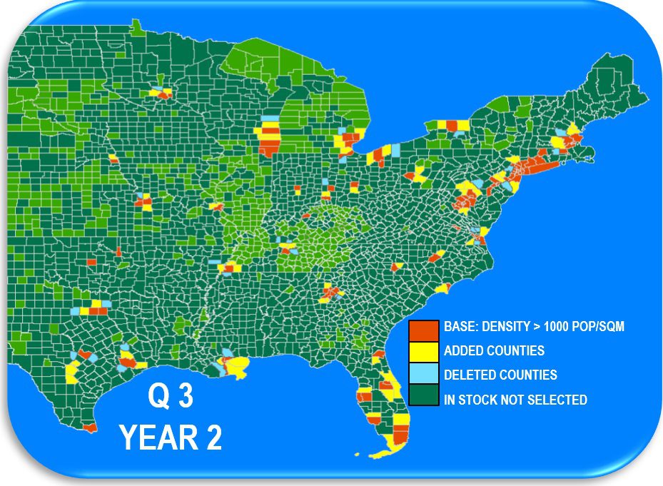
EXAMPLE: BASE VIEW – Only Counties in METROS w. DENSITY > 1,000 POP /SQM
Since the beginning of the year, well heeled new ParcelAtlas Subscribers who MUST have access to LIVE parcel data all over America, they just don’t know when or where, have opted to pay for all 2600 counties for 365 days a years under a NATIONAL ParcelAtlas Subscription. Despite BSI’s full freight live data National Subscription price being but a fraction of the competition, very popular among the new subscribers is ParcelAtlas WHEN NEEDED, paying a whole lot less for just what is needed when its needed. ParcelAtlas WHEN NEEDED is an exclusive BSI offering. Others can provide only downloads with no control on use after delivery [high prices to match]. ParcelAtlas offers an ArcGIS Online VIEW that can be real-time modified, adding and deleting counties AS NEEDED, billing only for what is used when it was used. Several WHEN NEEDED subscribers, playing a careful shell game, have had use of up to 3X as many counties without exceeding their annual BASE Price [20 county minimum]. Go to our QUOTE PAGE to find out the price of your initial ‘BASE VIEW’.
● ● ● ●
ParcelAtlas is the only national parcel layer content service INSIDE ArcGIS® Online, weighing in at almost 3000 counties, 150M parcels enhanced with industry leading Quantarium Property Attributes updated weekly. As for functionally, its analytical ability is limited only by the subscriber’s mastery of ArcGIS Pro. Subscriptions are for Live Data, but REST Subscriptions are available at commodity prices, easily implemented using the vast array of ArcPro tools.
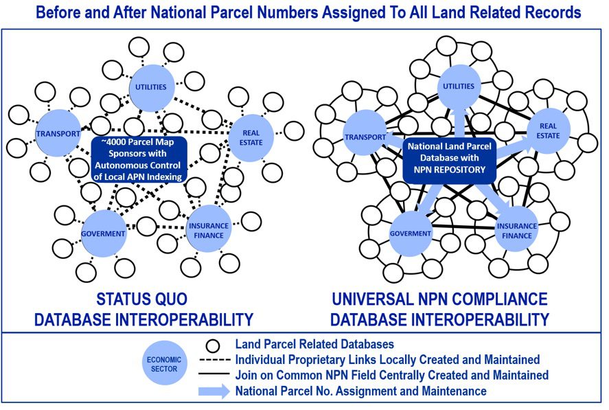
ParcelAtlas is home of the nation’s first National Parcel Number Repository. Created out of necessity (single Feature Services inside AGOL cannot be updated without it), each parcel is assigned a no-cultural-bias machine-driven number. Keeping the NPNs current for almost 3 years, combined with incorporation of already internationally recognized open source Plus Codes, the NPN National Repository was recently ELEVATED by Open Geospatial Consortium from a Candidate Standard to subject of an ad hoc OGC NPN Standard Working Committee (SWC). This increased recognition may speed up Universal NPN Compliance, a globally unique, persistent ID is assigned to every US land parcel and land-related record. Then, not just watch a revolution in improved accountability but how the increased interoperability enabling far more reliable Real Estate predictions causes a surge of more money flowing to GIS dependent markets. Don’t miss NPN Assignment Service FREE coming to Esri AGOL MarketPlace to get your nose in the tent early to better understand the profit storm ahead between now and Universal NPN Compliance.